


La Marolle en Sologne_ villeny_20181007

lemuid
User
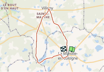

Length
13.4 km

Max alt
138 m

Uphill gradient
117 m
Km-Effort
14.9 km

Min alt
101 m

Downhill gradient
117 m
Boucle
Yes
Creation date :
2018-10-07 06:58:41.435
Updated on :
2018-10-08 14:43:05.263
3h02
Difficulty : Very easy

FREE GPS app for hiking
 SityTrail
IGN / Geographical institutes
SityTrail Plus
The world is yours!
About
Trail Walking of 13.4 km to be discovered at Centre-Loire Valley, Loir-et-Cher, La Marolle-en-Sologne. This trail is proposed by lemuid.
Photos

Positioning
Country:
France
Region :
Centre-Loire Valley
Department/Province :
Loir-et-Cher
Municipality :
La Marolle-en-Sologne
Location:
Unknown
Start:(Dec)
Start:(UTM)
408233 ; 5270854 (31T) N.
Comments